Love Lane: An ancient footpath reopens for Oxford Open Doors
On Saturday 13 September, as part of Oxford Open Doors, there will be an opportunity to join guided walks of Love Lane, a city-centre footpath closed to the public since 1910.
Drop-in (first come, first served) walks should take about 15 minutes and are supported by Oxford City Ramblers. For more details about the event, follow the link below.
A short history of Love Lane by Malcolm Graham
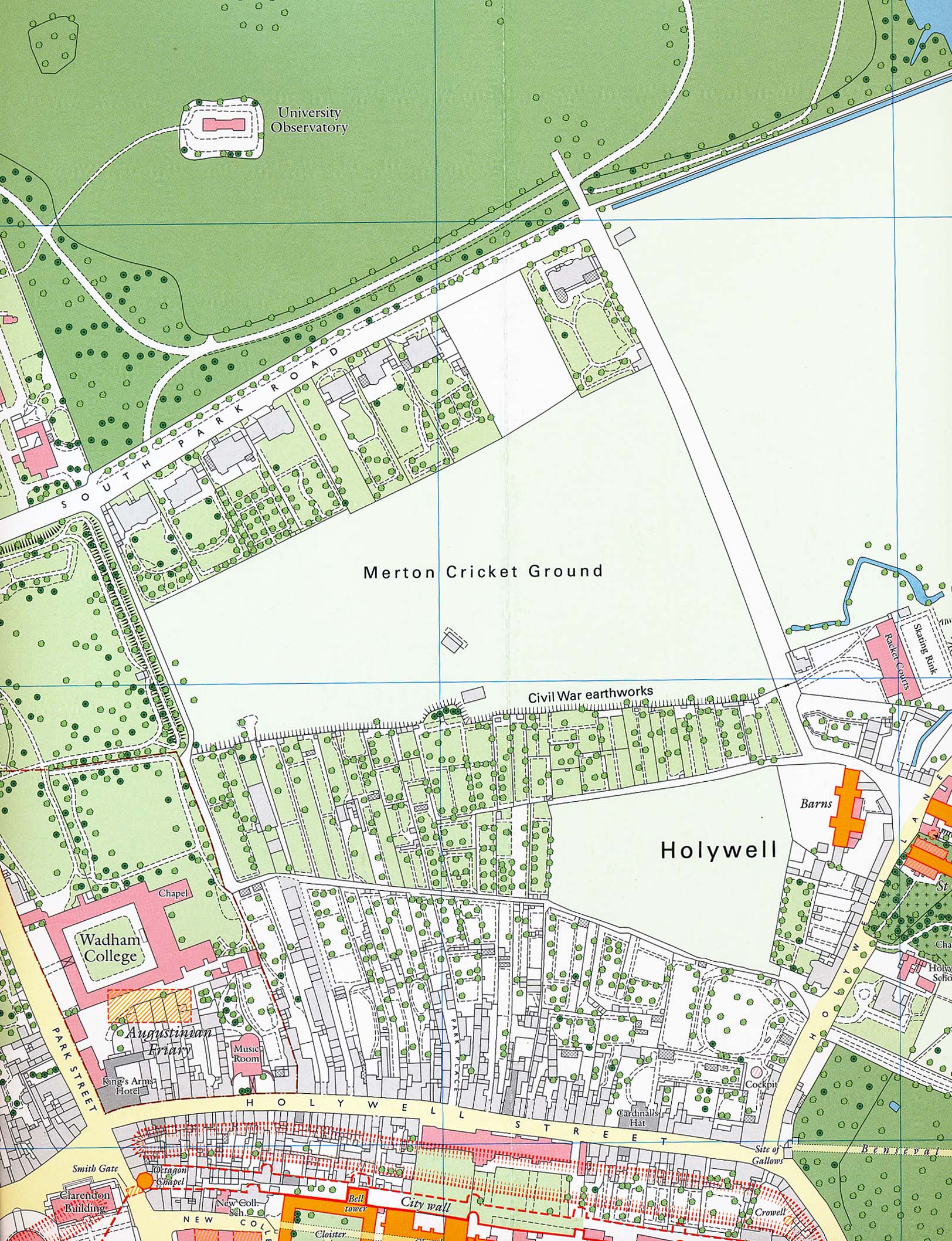
Love Lane was an ancient footpath which ran west from what is now St Cross Road near Holywell Church to the Augustinian Friary on the site of Wadham College and then north to the Parks. It provided access to fields now occupied by the University Parks and the Science Area, and it also formed a short cut between Holywell village and Holywell Street by way of Park Passage, the southern end of today’s Mansfield Road.
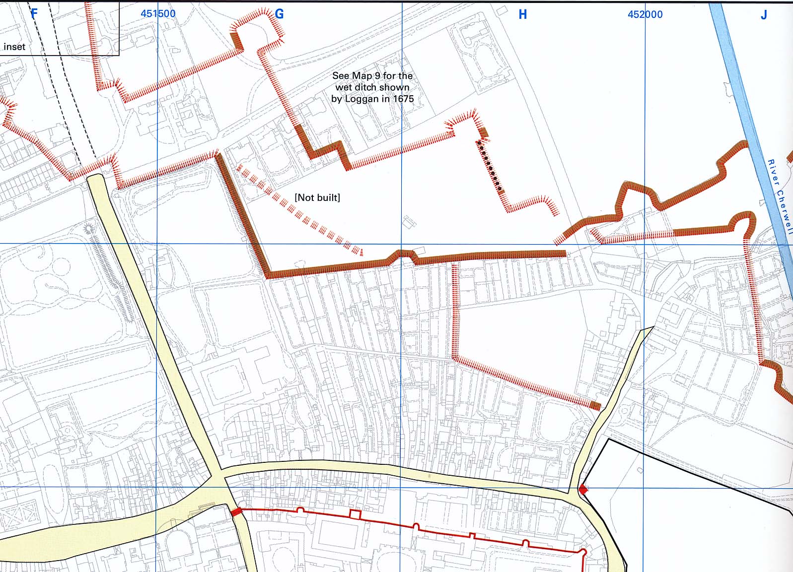
While Oxford was the Royalist capital during the Civil War (1642-6), the inner line of the city’s northern defences would have blocked the footpath. Part of this line survives as an embankment alongside Love Lane in Wadham Fellows’ Garden and Rhodes House garden and must have caused the kink in the path as you head north towards South Parks Road.
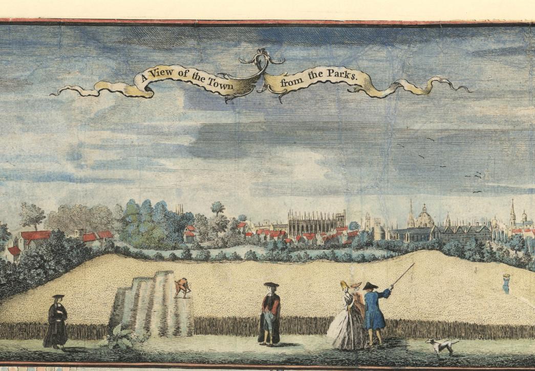
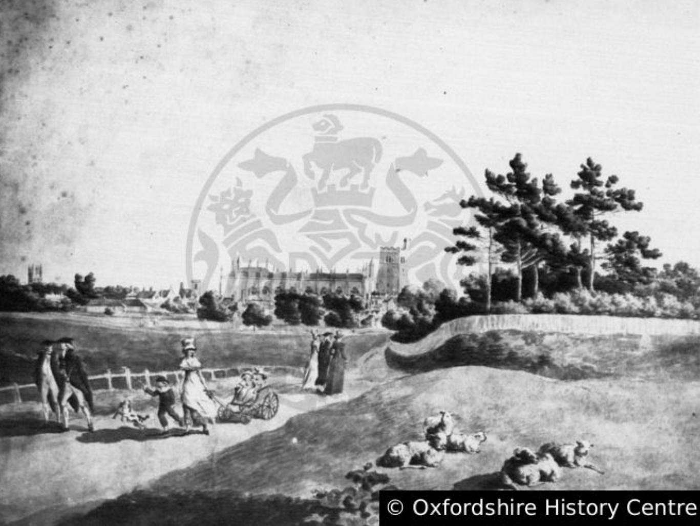
Love Lane was probably used for recreational walks from the earliest times, and the name must reflect its appeal for courting couples. An illustration in Isaac Taylor’s map of Oxford in 1750 (main image, credit: Oxfordshire History Centre - Oxfordshire County Council) shows academics walking along the path and a gentleman pointing out Oxford’s towers and spires to his female companions while a labourer works in the corn field. William Jackson used this view as the masthead of early issues of his newspaper, Jackson’s Oxford Journal, established in 1753. Love Lane was ‘beautifully repaired’ in 1755 to form ‘a neat Terras Walk’ and it became a University Walk, maintained by the University through a tax on resident members of the University but freely accessible to everyone. Initially, the walk went as far as the junction of Banbury Road and Parks Road with the option of completing the circuit by returning along Parks Road. During a hard winter in 1820, it was extended into a five-mile circular route when a large sum, raised by subscription, paid unemployed men to build raised footpaths beside the Banbury and Woodstock roads. Five Mile Drive and a raised section of pavement near Woodstock Road roundabout are surviving reminders of that work today.
Until the mid-19th century much of Holywell parish remained remarkably rural with just a cluster of buildings around Holywell Church. In 1892, G. Simms recalled Holywell as ‘a beautiful shady, arbourous (sic) place’ with many large trees, especially elms, chestnuts and poplars. He described a fine row of elm trees in Love Lane behind Charles Symonds’ riding stables in Holywell Street, and one of the largest elder trees in the county on what was to become the site of Mansfield College. Symonds’ stables, catering especially for students ‘more interested in hunting than schools’, became a substantial business with a cottage and loose boxes for horses beyond Love Lane where New College School is now.
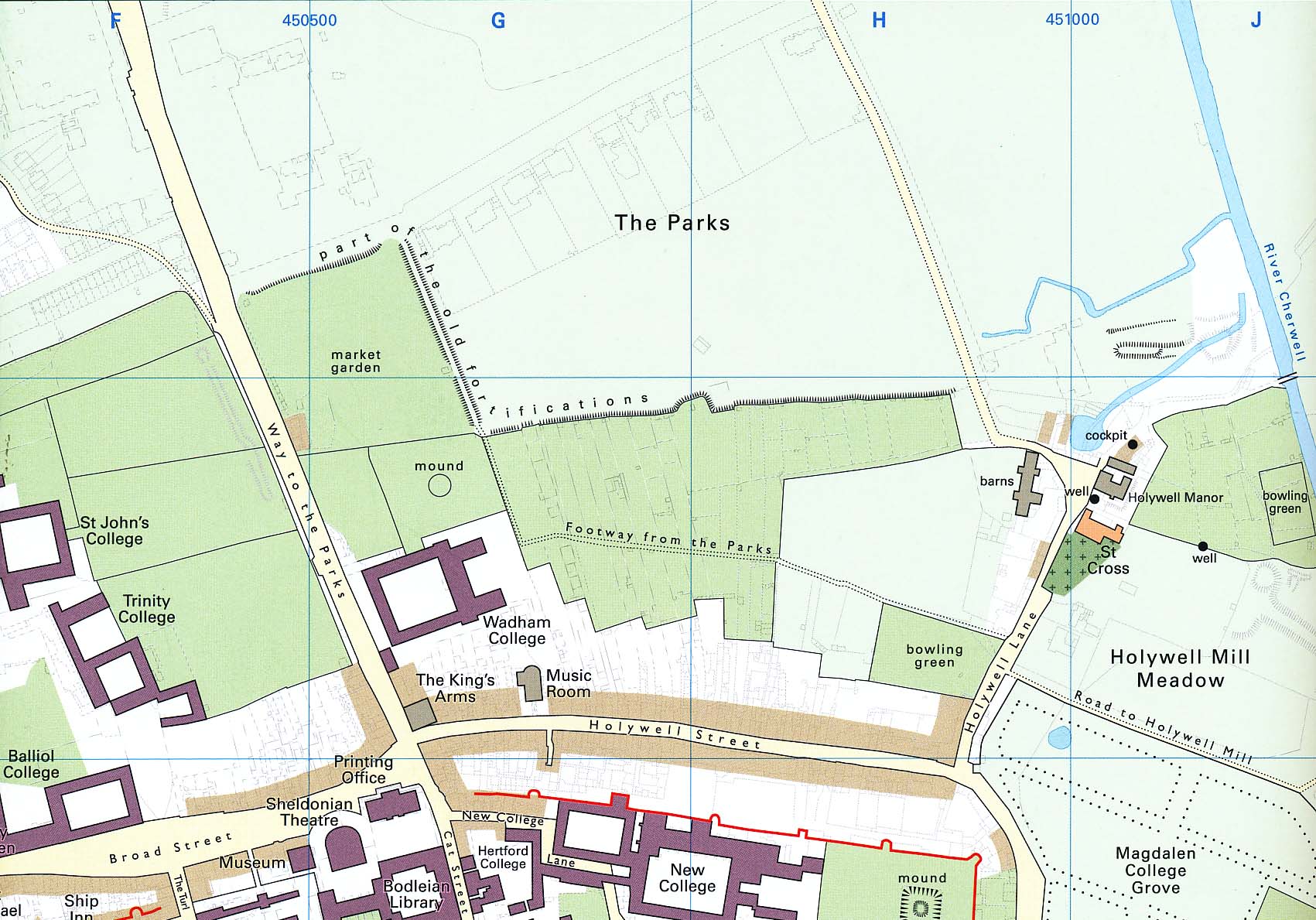
Rural Holywell began to disappear after the University acquired land from Merton College for the University Museum and the University Parks between 1853 and 1864. Merton College, probably encouraged by the progress of the St. John’s College building estate in North Oxford, made plots available for large villas on the south side of what was to become South Parks Road in the 1860s, leaving space for a new road – eventually Mansfield Road – leading towards Holywell Street. As Varsity sport became more important, cricket pitches began to take over Holywell’s green spaces and Merton’s cricket ground initially occupied the whole area between Love Lane and the modern St Cross Road. The sale of the western part of this cricket ground for the new Mansfield College led to the building of the first section of Mansfield Road in 1886.
Love Lane had by this time acquired an unsavoury reputation and, in 1890, Alderman Wilson remarked that ‘he had himself witnessed disgraceful conduct in the lane.’ In order to maintain law and order, he claimed that the City Council would need ‘to have a policeman permanently perambulating the lane night and day.’ The ‘narrow passage’ also provided an unimpressive western entrance to Mansfield College when the college opened in 1889. A proposed extension of Mansfield Road towards Holywell Street promised a well-paved and lighted alternative to the part of Love Lane running alongside Wadham College wall. Agents apparently working for several colleges applied to the City Council to close this section of the path in the autumn of 1890, and the closure order was confirmed at Oxford City Quarter Sessions in January 1891. No objections to the order had been made, but during the City Council debate the previous October, Alderman Eagleston had commented that ‘closing rural footpaths and places that had belonged to the public for ages’ was an important issue throughout the kingdom.
The rest of Love Lane was soon lost or altered beyond recognition. East of Mansfield Road, Balliol had purchased land from Merton College for a tutor’s house and a cricket field between 1889 and 1891. The section of Love Lane between Mansfield Road and St Cross Road was initially retained, ‘eight feet wide, unlighted and bordered by a hideous palisade.’ After the death of Benjamin Jowett, Master of Balliol, in 1893, the College decided to commemorate him by extending the cricket field across Love Lane to a new road, Jowett Walk, which was approved in 1894. West of Mansfield Road, Manchester College acquired a large plot of land between Holywell Street and Love Lane in 1890. It was already anticipated that the path here would be laid out as a wide street and that happened in 1903 when New College School moved from New College Lane to what became Savile Road.
The section of Love Lane outside Wadham College, gated and closed to the public since 1891, is as near as we can get today to the character of the ancient footpath. Open Doors 2025 therefore provides a unique opportunity to travel back in time!
Malcolm Graham
August 2025